For anyone interested, I'll give my insight into the trail and some general thoughts on the trip as whole... Hopefully Dryside will do simular.
To get it out of the way immediately, I would NOT recommend doing what we did in terms of how the trip was approached. A
long drive day, followed by a
full day of difficult wheeling, topped off with
another long drive day back home, in retrospect is not particularly enjoyable. Don't get me wrong, I'd do it again tomorrow; but next time I'd like to spend at least a couple of days on the trail to really take it in, similar to the Rubicon. It deserves more.
The first thing you have to know, and respect, about Fordyce are the water crossings. PGE, the California power company, has sole control over the flow rate and therefore you need to do your research on how it's trending before you solidify your plans, as PGE can change it at any time and it's not consistent year-over-year. I'd been watching it like a hawk for weeks and while it was generally trending downward in our favor, based on some vague information the flow was still a little higher than I wanted... The general consensus is that flows of 300cfs or less is considered passable. Lots of folks tolerate more, and it makes for great footage, but 300cfs seemed to be the metric during my pre-trip research. Flow information can be found here:
https://www.dreamflows.com/graphs/day.063.phpThe trail itself is approximately 12-miles in length, and can be broken down into 3 sections of roughly equal distances:
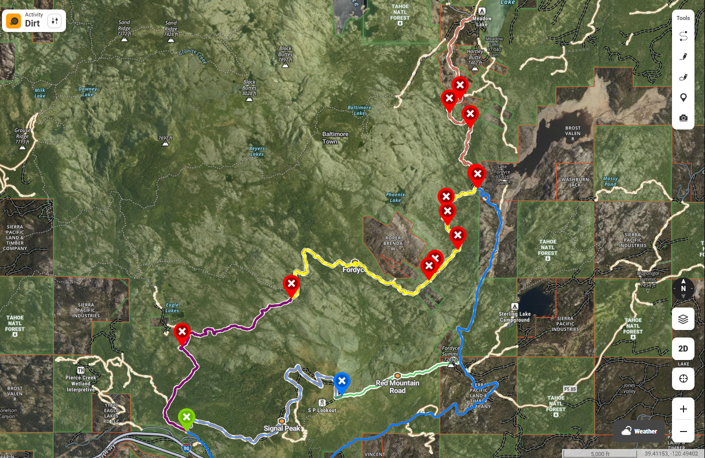
- fordyce.jpg (522.87 KiB) Viewed 1521 times
* Staging Area to Water Crossing #1 (purple section)
* Water Crossing #1 to Committee Corners (yellow section)
* Committee Corners to Meadow Lake (salmon section)
For our trip, based on the flow rate information still bumping up against 400cfs, the plan was to run the first section to Water Crossing #1 and then turn around and head back to the staging area (green pin). From there, we'd just run the nearby Signal Peak trail (light blue) to finish out our day. Clearly that plan changed
 Staging Area to Water Crossing #1 (purple section)
This section of trail is a great mix of dirt and mild rocks. The one notable obstacle along the way is Driveline Hill, marked as the first red pin as you generally head North on the map above. Good or bad, it's a pretty gnarly rock face that has clearly been torn up over the years and continues to degrade as people abuse it. At one time I'm satisfied this was just a difficult but very doable obstacle for your average user, but with bigger tires and more Coors Light taking over the trails it has become a destination for people to showcase their, uh, talents

There is a bypass around the obstacle that we chose to take instead, as our timeline was truncated and we simply didn't have the desire to make trail repairs caused by raw stupidity.
We meandered our way to the first water crossing. Once there, we took stock of the river and after some pondering, decided that it didn't actually
look all that bad, despite the posted flow rate being almost 25% higher than what was generally accepted as passable

We looked at each other, looked around, threw some rocks... Let's be honest, we hadn't come this far to not
at least put the tip in... We went for it
 Water Crossing #1 to Committee Corners (yellow section)
This section of trail contains the real meat and potatoes of the deal: Water crossings #2 and #3; as well as Winch Hills 0.5, 1, and 2. The deeper you get into the trail, the more difficult it becomes. The rock sections get bigger and nastier, and water crossing #2 is markedly deeper and swifter than #1. Surprisingly, for all intents and purposes, Water Crossing #3 was a non-issue. Again referring to the map, now in the yellow section of trail and continuing generally North, the red pins indicate these obstacles in order: Winch Hill 0.5, Winch Hill 1, Water Crossing #2, Winch Hill #2, and Water Crossing #3.
Winch Hill 0.5 has two obvious lines, with the line on your right being the more difficult. Overall this was an easy piece of work for both of us as we took the easier line on the left and continued on up the trail.
Winch Hill 1 was a non-starter for us, as similar to Driveline Hill its just been torn up over time. The actual wedge obstacle at the top looks very drivable, but the approach to get there is full of 2-foot diameter cobble with lots of smaller rocks and loose soil that just makes it a disaster. It's difficult just to walk on... After a not-so-brief discussion, we chose the bypass.
Water Crossing #2 was a little more intimidating than the first crossing had been, as it was obviously deeper and there was more audible flow from a drop-off just downstream of the line across. Overall it was my favorite crossing, and definitely got the juices flowing. Mike's 6.0L apparently ingested some water and got bogged down partway through, but he managed to keep it running and limped across.
Winch Hill 2 has a variety of line choices from mild to wild. I didn't even bother trying anything but what appeared to be the easy line that hugs the ridge of the rock face on your left as you squeeze past the tree on your right, since we were approaching 6-hours on the trail at this point and didn't want to risk spending the night

Neither of us had any issues here.
Water Crossing #3, traditionally the last water crossing on the trail, was mercifully meek in comparison to the previous two. Still more than hub-deep, it was good clean fun and included an element of nature brought about by low-hanging branches and brush as you splashed across. At this point we knew the end of our trail day was near, as Committee Corners was just up ahead...
Committee Corners to Meadow Lake (salmon section)
Although we didn't traverse this section of trail, we know it contains the remaining three Winch Hills and just gets harder and harder as you go. Knowing this, we chose to find our way off the trail via the Committee spur that, unfortunately again crosses the river and eventually ties you into the main FS road back down the mountain.
Committee Corners Trail ExitNow, in fairness, my research on the matter was lackluster but the reality is this: Committee is
NO JOKE. To my knowledge, the intent of this spur is primarily to allow club members to quickly access the main trail during the Sierra Trek event to bring in supplies, spotters, and stuff like that. In my head, this meant it must be a relatively easy section of trail... Holy moly was I wrong on that one

As we stood on the North side of the river, looking at the Committee water crossing, it simply felt impossible. You could
feel the water rushing by, the noise was deafening, and with 7+ hours already having clicked by, our options were pretty limited if we wanted to get back to the trucks/trailers much before we needed to leave for the long road trip back home

After much debate, we decided to give it a go. For just a touch of safety, and because Mike was still a little leery about his 6.0L stalling out again, we hooked my winchline extension to my rear bumper and attached that to his spooled-out winch, giving us plenty of lead to get my Jeep across while Mike was safely on the North river bank. At least that was the theory

Mercifully it all worked out, and while it was the defining moment of the trail for me, I'm happy to say it was successful and we eventually clawed our way across the river and up the other side to find the extraordinarily well-maintained FS road.
Overall, the trail is incredible. The scenery tops the Rubicon in my opinion, and the difficult sections of the trail are on par with the Rubicon for certain. I'd wager that the upper section and associated Winch Hills may be more difficult? There is ample parking for trucks/trailers at the staging area, and there were a number of very nice looking campsites along the trail. Although I'm not certain what the official trail exit looks like or exactly how to get back to the staging area from there, it appears to be a pretty substantial road trip so that is something to consider as well when choosing your route. I'd like to run the entire trail at some point, taking a couple of days to do so, and look forward to that opportunity