Ummm. . .the best laid plans.
I'll put this down:
We had FUN. The weather was PERFECT. No cable was pulled. The trails were GNARLY. There was no breakage that wasn't present when we started. My Jeep has a name: Popcorn. Not just because it is white. . .
1x wrong turn and one misunderstanding. . .
BTW: Toby, we're home. Please post up when you clear the threshold.
Pics and stories to follow.
No Name Run V2.0 Run Report
Well. . .
I'm hoping the run is over! I haven't heard from Toby since we parted ways in Thorpe.
Here's my version:
Jessy and I cruised over and picked up my folks then swung by Toby's joint to join the convoy at around 7AM. We were joined on the hiway by his folks.
So, We had:
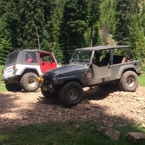
Moss Clan x3 generations: Rollin' in Popcorn (4 door xj blanco)
Mr. and Mrs. Chuck and Pam: White 2 Door XJ
Toby/Shannon/Lilo/Stitch: Blue Prevost Bus
After a quick stop in Yakima for a burrito and dropping off Chuck and Pam's trailer in Naches, we headed to the FS1901 parking lot to air down. The plan was to run Upper Kaner from Lily Pond to the top of Quartz Mountain, take some killer photos along the way, then roll down FS31 to Tripod, up to the Rocks to see who won the bet on what color the busted yota in the crack was, then down the Bald Mountain Road to Nile. . .easy enough. . .
We went ahead and started rolling up the 1901 to bypass lower Kaner. As soon as I put Popcorn in 4x4 mode, the transfer case started popping. . .it was loud and slightly disturbing but since it only did it in 4wd, we decided to run it and if it let go, we'd use our resources to get it back home or at least onto Chuck's trailer.
Up we went. . .and, well, After you take the right turn on the 1901, it is the 7th second right, not the 6th third right to get to Lily pond!! We accidentally ended up right above Elephant Dung hill by the sidehill on the approach to Aardvark.
Needless to say, we decided to check out Aardvark and make the call on weather or not to backtrack and find the correct road to Lily Pond. A few clicks and pops later and our crew of Soccer Wagons found it self staring at the beast. . .
Aardvark is MUDDY. . .and in worse shape than I have ever seen it. To say that it was slippery would be a massive understatement. In fact, the lower section that you can usually just crawl was an absolute mess. The bypass looked horrible and the mail line wasn't even a thought. . .at least not for my wounded popcorn popper with open diffs . . .
Did I mention that my parents were in the Jeep with me? So, of course, we did the right thing:
We climbed the friggin' hill. I'm not entirely sure if there are any photos, but I can promise you that there is a lot of seat upholstery where it doesn't belong this morning.
Toby went first and even with both lockers engaged needed a little momentum to clear the bottom section. On the bottom section, I tried about 22 different lines to crawl, but with the front end unloading and the popper in full tilt, crawling wasn't cutting it. So, we had to really push the poor little loaded down mall crawler to get past the first section and pull up behind the Prevost.
Now, I guess that discretion and valor don't always mix, because Toby hung his head out the side and said, "Just one time. . ." and pointed the beast up the main line towards "the root". It was easy to see since it was totally polished and very wet. . .
While he started up that way, my clutch leg was getting tired so I let her rip up the bypass. My guess is that the bypass will be 90% as hard as the main line in a year. I made a couple of good (lucky?) choices on line selection and didn't stop until I got to the meadow at the top of the hill. I did notice a certain large blue bus with a tire about 4 feet in the air on my way by though. . .
Chuck cleaned it with no drama (old guys rule. Period>.) and we regrouped to unbunch our panties before catching the fire road, hitting up Lily Pond and then starting on our PLANNED route for the day.
The worst behind us and the weather on our side, we stopped for a wonderful lunch at the main intersection at the top of upper Kaner just below the ridge. When you finally see the pictures, we have a challenge of identifying a creature that looks like a long tailed chinchilla. . .
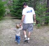
The kiddos, young and old, had a fantastic time playing around our picnic area. The smell from the BBQ was intoxicating. . .
On up the trail with zero drama to the top of Quartz Mountain. . .even with the slight chill in the air and a tiny bit of haze, I am pretty sure you can see the Sears tower and Mt. Everest from up there. Fantastic!
Our happy little group then wound our way past numerous deer hunting camps with a lot of "hunters" drinking beer around their campfires. We actually saw 5 deer about 100 yards from one of these compounds, but don't tell the hunters. . .
Now, for our second mis-step of the day. FS31 is closed from both directions. . .We thought that you just couldn't get in from Eburg. . .From the other direction, it is closed right at Tanum Creek at Buck Meadows. . .about a mile from the Tripod trailhead. . .so, we were screwed.
Chucks trailer was in Naches and, after a conversation with some hunters, we learned that Thorpe was our only way out. That is the big fruit stand West of EBurg, for those of you keeping score.
The road from FS31, FS3111 to FS3330 and down into Thorpe is MISERABLE. It is sharp cobblestones with water bars for miles and miles and . . .you get the picture.
At any rate, we aired up at the pavement at the Exit to the WOD wildlife area and cruised the blacktop from there. Our crew made a brief Starbucks run and headed home via Vantage will the other two made their way back to Naches for the wayward trailer.
Everyone is home safe and sound, Popcorn got a name, we had a GREAT time with great people and perfect weather. Nobody pulled cable and we managed some fantastic chow. Overall, it was GREAT for me to get my parents back on the trail and they had a great time. The Sr. Wilcox are wonderful peeples and I can't wait to wheel with them again. Sir Chuck has secrets to share.
BTW, just heard from Toby. . .so stand by for his commentary and photos. Poppy should have his up before long as well.
I'm hoping the run is over! I haven't heard from Toby since we parted ways in Thorpe.
Here's my version:
Jessy and I cruised over and picked up my folks then swung by Toby's joint to join the convoy at around 7AM. We were joined on the hiway by his folks.
So, We had:
Moss Clan x3 generations: Rollin' in Popcorn (4 door xj blanco)
Mr. and Mrs. Chuck and Pam: White 2 Door XJ
Toby/Shannon/Lilo/Stitch: Blue Prevost Bus
After a quick stop in Yakima for a burrito and dropping off Chuck and Pam's trailer in Naches, we headed to the FS1901 parking lot to air down. The plan was to run Upper Kaner from Lily Pond to the top of Quartz Mountain, take some killer photos along the way, then roll down FS31 to Tripod, up to the Rocks to see who won the bet on what color the busted yota in the crack was, then down the Bald Mountain Road to Nile. . .easy enough. . .
We went ahead and started rolling up the 1901 to bypass lower Kaner. As soon as I put Popcorn in 4x4 mode, the transfer case started popping. . .it was loud and slightly disturbing but since it only did it in 4wd, we decided to run it and if it let go, we'd use our resources to get it back home or at least onto Chuck's trailer.
Up we went. . .and, well, After you take the right turn on the 1901, it is the 7th second right, not the 6th third right to get to Lily pond!! We accidentally ended up right above Elephant Dung hill by the sidehill on the approach to Aardvark.
Needless to say, we decided to check out Aardvark and make the call on weather or not to backtrack and find the correct road to Lily Pond. A few clicks and pops later and our crew of Soccer Wagons found it self staring at the beast. . .
Aardvark is MUDDY. . .and in worse shape than I have ever seen it. To say that it was slippery would be a massive understatement. In fact, the lower section that you can usually just crawl was an absolute mess. The bypass looked horrible and the mail line wasn't even a thought. . .at least not for my wounded popcorn popper with open diffs . . .
Did I mention that my parents were in the Jeep with me? So, of course, we did the right thing:
We climbed the friggin' hill. I'm not entirely sure if there are any photos, but I can promise you that there is a lot of seat upholstery where it doesn't belong this morning.
Toby went first and even with both lockers engaged needed a little momentum to clear the bottom section. On the bottom section, I tried about 22 different lines to crawl, but with the front end unloading and the popper in full tilt, crawling wasn't cutting it. So, we had to really push the poor little loaded down mall crawler to get past the first section and pull up behind the Prevost.
Now, I guess that discretion and valor don't always mix, because Toby hung his head out the side and said, "Just one time. . ." and pointed the beast up the main line towards "the root". It was easy to see since it was totally polished and very wet. . .
While he started up that way, my clutch leg was getting tired so I let her rip up the bypass. My guess is that the bypass will be 90% as hard as the main line in a year. I made a couple of good (lucky?) choices on line selection and didn't stop until I got to the meadow at the top of the hill. I did notice a certain large blue bus with a tire about 4 feet in the air on my way by though. . .
Chuck cleaned it with no drama (old guys rule. Period>.) and we regrouped to unbunch our panties before catching the fire road, hitting up Lily Pond and then starting on our PLANNED route for the day.
The worst behind us and the weather on our side, we stopped for a wonderful lunch at the main intersection at the top of upper Kaner just below the ridge. When you finally see the pictures, we have a challenge of identifying a creature that looks like a long tailed chinchilla. . .
The kiddos, young and old, had a fantastic time playing around our picnic area. The smell from the BBQ was intoxicating. . .
On up the trail with zero drama to the top of Quartz Mountain. . .even with the slight chill in the air and a tiny bit of haze, I am pretty sure you can see the Sears tower and Mt. Everest from up there. Fantastic!
Our happy little group then wound our way past numerous deer hunting camps with a lot of "hunters" drinking beer around their campfires. We actually saw 5 deer about 100 yards from one of these compounds, but don't tell the hunters. . .
Now, for our second mis-step of the day. FS31 is closed from both directions. . .We thought that you just couldn't get in from Eburg. . .From the other direction, it is closed right at Tanum Creek at Buck Meadows. . .about a mile from the Tripod trailhead. . .so, we were screwed.
Chucks trailer was in Naches and, after a conversation with some hunters, we learned that Thorpe was our only way out. That is the big fruit stand West of EBurg, for those of you keeping score.
The road from FS31, FS3111 to FS3330 and down into Thorpe is MISERABLE. It is sharp cobblestones with water bars for miles and miles and . . .you get the picture.
At any rate, we aired up at the pavement at the Exit to the WOD wildlife area and cruised the blacktop from there. Our crew made a brief Starbucks run and headed home via Vantage will the other two made their way back to Naches for the wayward trailer.
Everyone is home safe and sound, Popcorn got a name, we had a GREAT time with great people and perfect weather. Nobody pulled cable and we managed some fantastic chow. Overall, it was GREAT for me to get my parents back on the trail and they had a great time. The Sr. Wilcox are wonderful peeples and I can't wait to wheel with them again. Sir Chuck has secrets to share.
BTW, just heard from Toby. . .so stand by for his commentary and photos. Poppy should have his up before long as well.
Poppy's photos!! Name that mouse!! SteveR?? You gotta know what it is. . .
https://picasaweb.google.com/1000970437 ... ocked=true
https://picasaweb.google.com/1000970437 ... ocked=true
Last edited by OldGreen on Mon Oct 17, 2011 8:17 am, edited 1 time in total.


Wow. That pretty much sums up the day, for a few reasons:
• People. We had a wonderful mix of family and friends, spanning 3 generations for both the Moss and Wilcox clans!
• Scenery. The weather was outstanding, and we had stellar views in all directions the entire day. I don’t recall having such great weather for that length of a trip in the mountains; the old cliché’ of “…if you don’t like the weather in the mountains, just wait 15 minutes…â€
Yep, I've wheeled one of those, too...

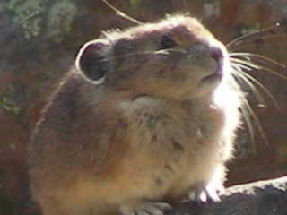

OldGreen wrote:It is a PIKA.
Ha, ha! When you wrote that earlier I thought you were correcting Grumpy's spelling of 'pix.'
Okay, we're a little crazy to have a Duramax for a daily driver. But if we go off our meds, we might wind up in a Prius.
If you want to hear God laugh, tell Him your plans.
N7EEL WROD249


If you want to hear God laugh, tell Him your plans.
N7EEL WROD249
-
I'm not so bright
- Posts: 132
- Joined: Mon Feb 07, 2011 7:56 pm
little confused You said
(As it turns out, the spring run-off washed away the land bridge over Taneum Creek)
You can't get to Tripod Flats by crossing Taneum Creek Did you mean
Manastash creek @ buck meadows.
If you kept going past buck meadows and took the first jeep trial to your right it would of took you down to buck meadows and the wooden bridge across Manastash creek creek and out to Manastash road ! To bad you missed it, the trial from tripod is just starting to get good.
Here's a pic of the bridge
I will be going up there early November Hoping for Snow/mud/water/ice/mud/snow
You are correct about the creek.. .however, FS31 is washed out at the creek and there are not only Jersey barriers but a giant hole in the ground with exposed culverts. We know where Tripod is.
The closure is at the junction of FS3100, 3111 and 31. 3100 and 3111 are open, but 31 is CLOSED at Buck Meadows.
And as far as Tripod "getting good". The only time Tripod is good is when the weather is crappy. Other than that, it is just a freeway to get to the other trails.
The closure is at the junction of FS3100, 3111 and 31. 3100 and 3111 are open, but 31 is CLOSED at Buck Meadows.
And as far as Tripod "getting good". The only time Tripod is good is when the weather is crappy. Other than that, it is just a freeway to get to the other trails.
-
I'm not so bright
- Posts: 132
- Joined: Mon Feb 07, 2011 7:56 pm
benw wrote:Oopsy, that closure has been pretty well publicized online for months and months. Bummer your trip got cut short.
I knew that FS31 was closed from E-burg up, but I wasn't sure where exactly the washout(s) were... Where is there detailed online info on the washout locations? Is there similar detailed info on the washout locations for Milk Creek road? This would indeed be helpful...
Yep, I've wheeled one of those, too...
I usually check the most recent recreation report for closure updates. http://www.fs.usda.gov/Internet/FSE_DOC ... 307909.pdf
Milk creek is closed from hwy410 to FS590. You can run Lily Pond trail to Milk Creek then up to 5 fingers or vice versa. You just can't go any further down Milk Creek than the 590/Lily pond intersection.
Milk creek is closed from hwy410 to FS590. You can run Lily Pond trail to Milk Creek then up to 5 fingers or vice versa. You just can't go any further down Milk Creek than the 590/Lily pond intersection.

October 16 run.
Amma and Poppy had a great time. Can't wait to do it again.
Great pictures Toby. Thanks
Great pictures Toby. Thanks
Who is online
Users browsing this forum: No registered users and 2 guests